The Pages Expedition – KI South Coast – 21 – 26 April 2023

Day 1 and 2  – Victor Harbor to Pink Bay via The Pages

Karl Meyer, Ben Weigl, and Tresh Pearce met up at Pink Bay. Ben had earlier paddled solo from Cape Jervis, arranging to camp overnight along with the Adelaide Canoe Club (ACC) crew including Karl and Tresh. He had set up camp there before the weary ‘Pages’ paddlers landed late on Saturday 22nd April.  They had completed an epic ACC paddle from Victor Harbor to Ballaparudda Beach, camping overnight then on to Pink Bay at Kangaroo Island via the ‘Pages’ group of islets in Backstairs Passage. The trip was recently well-documented by Greg Adams from the Club.

Day 3 – Bay of Pinks to Pennington Bay

Breaking wind-against-tide clapotis around Cape Willoughby

The next day saw the trio set off for a further westward adventure around Cape Willoughby and along the South coast of the Island, aiming for Vivonne Bay. The remains of the ‘Pages’ expedition enjoyed a relaxing day before they headed to Antechamber Bay in the afternoon.

After launching and farewelling our comrades and the homely Bay of Pinks, we set our sails in the strengthening but still moderate easterly toward the nearby Cape with the awesome sight of its presiding lighthouse coming shortly into view. We knew we had missed the slack tide conditions and expected the wind-against-tide factor to come into play in rounding the Cape, causing rough sea conditions. This would be on top of the ever-present clapotis from the ocean swells in deep water meeting the sheer boulder cliffs under the lighthouse.

As we approached under full sail, the comments of James Fishers came to mind when he said during his and Dayna’s rounding of the Cape in 2022: that “it was the most hectic sea conditions he had ever paddled in”.  . . . . .  Well, that is pretty much what we experienced too. It was so concentrated and boiling with big breaking slop making for hectic and scary discomfort. I had been around the Cape a couple of times previously, but the conditions were nowhere near as severe then. The sails were good for providing the steady power to make headway through the clapotis paddock, as it seemed as though our paddles weren’t having much effect!  As well as going through the motions of forward stroking, they were being employed in bracing and keeping us upright.
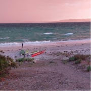
Pennington Bay

Apparently, some or all of the ACC crew were walking to the lighthouse and saw us go through that. Greg Adams later said that seeing us set our sails for Cape Hart once we were through, was an inspiring sight. I’d say that for those of us on the water, once it had all sorted itself out after a km or two, it was more of a relief and then a deep pleasure to find ourselves with a steady breeze behind us, and we were away!

After an extremely pleasant sail around Cape Hart with its magnificent surf rolling onto the reefs, we rounded Black Point then eventually False Cape and were into the big indent of coast of Pennington Bay. The sea was often lumpy, the coastline magnificent.  After False Cape (and Black Point earlier), there are many beaches. So the clapotis disappears for a while and one can mosey along quite close behind the break. They were all breaking very close to the steep sandy shores. – evidence of extremely high-energy beaches. There may have been places to land but we didn’t see them.

Approaching Pennington it was getting on in the afternoon and we briefly looked for a small cove immediately west of the main beach, but couldn’t find it. Sometimes beaches disappear after wild weather, taking time to re-appear as the sand slowly redeposits. We chose the western end and landed through the moderate surf there onto an idyllic setting, sheltered and with the last of the sun disappearing behind the cliffs. It wasn’t cold at all and we were in high spirits at our good fortune in making it safely and very happily during our first leg.

Day 4 – Pennington Bay to Unknown Cove (A real Gem)

Camp in the D’Estrees Unnamed Cove

Shortly after leaving Pennington Bay my rudder became ineffective, a cable issue somewhere. Karl fixed it into a neutral position and I managed to sail and paddle using the stern rudder to keep on course in the steady easterly / northeasterly breeze. I could also keep my hands way off-centre of my paddle to lengthen the stroke on one side if necessary, but we mostly sailed. Upon landing it proved to be easily fixed with a minimum of tools.

Outside of this great little bay there were some awe-inspiring-looking breaks on the protecting reefs which we could get up close to and have a good look at. We waited around for Karl to do some surfing on the shoulders of them – so perfect were they. Alas, although we waited a good while, the sets didn’t return and perhaps we’d drifted from the best spot, so Karl has to wait for another opportunity!

Although none of us had direct experience of this cove, or knew anyone who had landed there (it just looked terrific from satellite maps), our bay turned out to be a real gem. We settled on the southern end of it, and made a delightful camp amid warm balmy conditions. At last we were in pristine country only occasionally visited by walking humans.

Day 5 – Unknown Cove near to bay near ‘Pogaroo’ Bay

That day was to be the pivotal day where we left all land-based accessibility along the Cape Gantheaume Conservation Park wilderness area. It really is heading out into the wild. We still had the most amazing conditions anyone could ever pray for: moderate swell and helpful breezes, not too strong, not too weak!

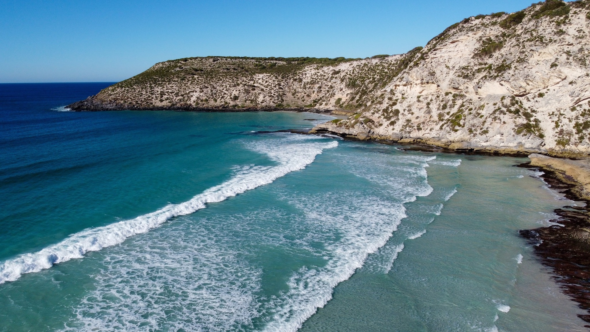
The little Bay just East of Cape Gantheaume

Not far from the Cape we landed in a little cove for an explore and a break. Now, theoretically there are no reliable unprohibited landing spots for sea kayakers before Seal Bay, meaning that Vivonne Bay should be the next landing. However Phil and Gordon had mentioned this little cove as a possibility (not sure if either of them had visited previously, but both said it was worth a look). It was very good to receive counsel from both of these very experienced expedition sea kayakers at different times before we set off along this Coast, I’m grateful that the accumulated pool of knowledge is so readily shared. We had also referred to the satellite images and seen the possibility, so gave it a go and it was perfect.  Good for camping too….. .. really, I’m talking perfect here. I think it has a large measure of protection from swell, however it would be scarcely visible from the usual half to a one kilometre offshore that most sea kayaking expeditions have to travel due to having to ‘get’ to Vivonne without dilly-dallying (our specialty) and the clapotis.  We had to share the bay with the resident sea lion population though!  We snacked there, and wandered around the breathtaking, but gentle cove, with a tiny hinterland of open shrubland.

Out to sea once more and we soon came to Cape Gantheaume. It is surrounded by many reefs but we paddled around them as the sea was calm. Although not a huge swell, there were many well-formed breaks all around the place.  The swell itself had a long interval and some were definitely 4 metres.  There were areas of reef that we were only 50 m from, a semicircle of Niagara Falls shape.  That is literally what it was like being near them from behind, it was not so much like waves breaking, but more like a waterfall going from high and falling into much lower ‘suck out’.  The continual roar even on this quiet day was ever-present and astounding, a constant reminder that nature is not to be underestimated, ever.

Eventually we come to our chosen landing and camp destination, a bay immediately before ‘Pogaroo’ Bay, which in turn is one bay before the better known Bales Beach. Our bay is the smallest by far of the three, and is protected to some degree. When we approached there were some significant swells rolling through. We spent some time happily watching it all to get the gist of how it works there. I say happily, because to watch is the safe part.  Yes, it had some big surf going on, frightening at times when the sets came. Karl opted to go in first, he threaded his way through, finding the beach exhaust flow in the middle left of the bay where even the big waves didn’t break. (Though we couldn’t see that from where we sat behind the breaks). He promptly set himself up on a high hill with paddle to sign for us go or not go. Very soon after, Ben and I waited for a lull, but the decent sized waves kept coming. Karl, high on the sand hill gestured most assertively with the paddle not to come as he could see what was happening behind us. We didn’t need to be told, we weren’t going anywhere for the time being.  One wave in particular was huge, Karl said later (he’s a longtime surfer) he was guessing at about 10 foot or 3m. Then there was a lull, and I could see the broken water outward with beach exhaust and rip centre left in the tight bay and thought “It had better be a decent lull or I’m cooked!”. It turned out to be what we needed and eventually on the same lull Ben set off inward. No waves broke at all along that line, which does a little dogleg halfway. The swell size seemed to diminish noticeably from that point on. We were all very stoked to have landed so successfully, with no mishap. After recceing the beach and surrounds we re-entered our kayaks to relocate into the very sheltered western corner of the bay a hundred metres away and set up another idyllic camp. The unnamed bay itself is extraordinary in its perfect half-moon shape with a narrow opening to the sea – very beautiful to behold. Being a gloriously warm afternoon helps no end too!!

We were now in the Cape Gantheaume Conservation Park some kilometres from the nearest road, but more recently a walking trail has been established nearby connecting with the D’Estrees end of the Park. From this site it was only approx 20 kms to paddle to Vivonne Bay on the following day, but there was still a lot of exploring to do in the morning even before Seal Bay.

Day 6 – Unknown Cove (near ‘Pogaroo’ Bay) to Vivonne Bay.

In the morning we set off to a much-diminished swell, cruising out of the centre of the bay without so much as a splash, the one to two foot reformed little shore-break near our camp was more splashy than the rip through. Passing the neighbouring larger bay directly adjacent to ours was also beautiful from our route a hundred metres off from its entrance. I was full of emotion as we passed Bales Beach:  so many swims there, and it continues to be a sacred part of my and others’ lives. In 10 days or so I will likely be there once again, and it seemed a bit weird with two completely differing contexts happening to overlap at that place.  The fresh north easterly breeze filled our sails and moved us along nicely toward Vivonne Bay.

With the wind coming in blustery from the NNE (before swinging more NE a bit later) we cleared Bales and the steep rocky cliffy shore once again resumed, though this time relatively protected by reefs a bit offshore.  A couple of micro coves presented themselves for inspection and possible landing. The first immediately after Bales proved a bit too unprotected, where there were dumpy breaks closing out its opening. I have visited there before on foot through the shallows on an exceptionally calm day and it is truly beautiful, and also accessible (just) by land. Has a very interesting honeycombed small stack that can be climbed around in to peep out of various windows!!  Not for today though. Karl and Ben went over to a potentially easier-to-explore area a bit further west, which was a cracker!  I won’t say much more about it, but this was definitely one of the trip’s highlights. Situated just outside the Seal Bay Exclusion Zone, It had a great many resident sea lions of all ages, including a bull. We had lunch and I can’t thank B & K enough for their decision to land there. (Even though in the forefront of my mind was the possible NW strong wind coming in before our scheduled close of play in Vivonne Bay around lunchtime).  This turned out to be a dire headwind, the NE intensified and came in early and made for a raging tailwind for the last hour.

After an interval with the seals and cubs and mammas and all sorts in the water and on the beach, we launched. At the point of launch intention, a mamma seal from the beach decided that she either wanted to inspect our boats a lot closer, or wanted to prevent them from entering the water, and blocked our path!  She was very intent on something, we waited until she drew away a bit. There is a pic of Karl entering the water and she is still a distance away by then but watching very intently. We did everything slowly, quietly and calmly.

Then off around the headland where we went inside the reef breaks threading our way, avoiding the locations where the bigger waves were breaking. There is always some tension at these times, the questioning…  “Have we got this right, or are we paddling into a disastrous trap?”  As we travel we check things out ahead for some distance, making mental notes, sometimes consulting maps for the locations of the reefs etc. And in the end, you either back your intuition using the evidence and visual based info, or be in undecided-land, waiting for a lull or trying to seek more evidence confirmation (sometimes this is the most appropriate) or even make the long back-track for a possible couple of kilometres.

Passing by Seal Bay beach we saw the paying tourists viewing the few seals on display there, whereas just around the corner there were lots (for no cost!) where we had just lunched among them.

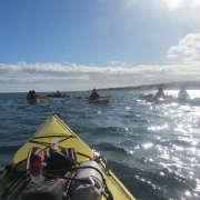
Ben Blue Water Sailing, near Seal Bay

The Nobby, (an enormous detached piece of Headland alongside a wide protected channel) loomed up, and I went ahead to position myself where I could get a good pic of Ben and Karl coming through the gap to show the whole massive stack, while having them clearly visible in the gap. It was my one intentional set-up photo. Trouble was, I only casually briefed them as I paddled off. . . .well I waited and waited as they stuck together moseying along doing their exploring and seal watching and filming, while I’m blown further and further away from the desired shot. I back paddle against the wind, they hug the shore at snail’s pace, completely indiscernible, camouflaged against the texture of the Nobby, and the whole of the towering stack no longer in frame with water on each side.  I find myself way behind them and with only rubbish pics to show for it.  I put the phone away, and declare ‘ *@%@$* photography !’ and paddle strongly to catch up.  From there it was only a few kilometres of easy sailing out from the cliffs to a point where we start to work out where we think Vivonne might actually be in the 10 km distance, amid the land on the horizon. Amongst us there were some differences of opinion concerning that, so time to consult the map!

During the last hour we found that heading for the jetty was hectic and exhilarating, but also scary for me as I felt I was going too fast at times. The conditions didn’t allow me to comfortably sheath one of my sails (requiring two hands off the paddle for twenty seconds or so) or just let it flap. I was ahead of Karl and Ben who found the pace perfect, paddling away as well as the effortless sailing. It was the first time I had truly deserted them, I let as much wind out of the sails as I dared, and looked back often and figured there were two of them together to help each in case of mishap, and I’m ahead of them, so that if something happens to me I can sort myself out, or they will see me and assist. When I arrived at the jetty it proved to be inappropriate for our landing needs, so I desailed and waited in the now raging wind for the others.  We beat our way a couple of hundred metres to the boat ramp, which proved ideal in every way.

Return to the Mainland

Three very Happy Paddlers at Vivonne Bay

Our trusted beach greeter Tristan – resident of Vivonne Bay, and later to be ferryman in his car to Penneshaw – was there to welcome us. None of us had ever met Tristan, but through a mutual contact he had kindly agreed to take on the ferryman task. I had been updating him throughout the previous week to firm up a time of arrival.

On the mainland we transferred the boats went to Ben’s ute, and were off into the falling night. Driving through the treed paddocks of Karls’ neighbour as a short cut to his spectacular place on top of the range was a highlight.  Threading through the trees was just like threading through the breaking reefs of earlier in the day ……. a million miles ago it seemed.

Tresh Pearce


Through Chowilla

Four day downstream meander in the creeks of the Riverland, 7- 10 Apr 2023

The River is Green

Five kayakers headed up to the Riverland to inspect the aftermath of the recent floods by paddling all the backwaters from the Chowilla Reserve back to just before Renmark, a distance of 68kms. Happily we can report that the river levels are back to normal, most businesses are open, and the whole area is looking magnificent: I have never seen it so green with so much bird life. If you can, get up there to have a look, the floods have done wonders for the countryside.

Good Friday

Charlie in the MurrayWe started our trip on Friday lunchtime from the launch spot near the Customs House Houseboats, crossed the river to get into Suders creek and off the Murray as soon as possible. Suders creek was its normal fast-flowing self, but now (thanks to the floods) with a new tree stuck right in the middle of the channel at the fastest spot, with associated eddies. This resulted in one capsize and a few near misses, not a good start to the trip! After getting organised again, we continued down the creek, avoiding the many snags to set up camp on Chowilla creek.

Leisure Saturday

A leisurely start next morning saw us paddling slowly down Chowilla creek, assisted by the current while we watched the scenery. A pair of wedge tailed eagles was spotted, along with many straw-necked ibis and the more common sacred ibis. We were also fortunate to see a lot of Black-tailed native hens, which we have never seen before. Apparently they are nomadic and take advantage of temporary wetlands, so the conditions after the floods must be ideal for them.

At the end of Chowilla creek we reached the Murray and turned left for a few kilometres to look for the next creek which would take us into Hunchee, and then RalRal creek. We stopped at the Chowilla Woolshed for lunch, where the full extent of the flooding became apparent; we were sitting on the bank at least 2 meters above the river, and could see the flood marks another 1 meter up on a building. Trying to estimate how wide the river would have been at the level was truly scary, I’m sure it must have been difficult to even find the main channel of the Murray at that level.

A Short Shower on Sunday

The third day dawned cool and overcast as the others had, but this time we were treated a short shower of rain, luckily we were all in our kayaks with wet weather gear on so we didn’t get much wetter than we already were. After turning off into RalRal creek we had a short detour to have a look at Lake Woolpolool, but the water levels were already too low to get over the regulator and into the lake itself. Maybe next time.

Portage in ChowillaJust after that there was a bit of excitement where the creek narrowed into almost a small rapid under a low bridge, with a tree waiting in the river downstream. With memories of Suders creek still fresh in our minds, some of us opted to do a short portage to avoid the obstacle, while the rest of the group took it in turns to carefully paddle through. Luckily it wasn’t as bad as it looked and no-one else went swimming.

After a leisurely paddle down the RalRal Wide Waters (which is actually a lake wider than the Murray itself), we found the entrance to Nelbuck creek and set up camp for the night. Peter put out his yabbie net and managed to supplement dinner with 2 nice size yabbies, although cooking them in a small hiking stove was a bit of a challenge.

Wrap up Monday

Next morning we continued down the creek back into the Murray and had a brief stop at the old Woolenook Internment Camp from World War II. Nothing much is left of it now except for a few plaques, but worth a look.

Another kilometre or so down the Murray and we found the imaginatively name Inlet creek, which we followed into Horseshoe Lagoon, and from there navigated our way through the creeks and lagoons back to Canoe-The-Riverland, where Ruth and Jim had kindly let us leave one of our cars for the shuttle back to our launch spot.

If you feel like a paddle in the area, be sure to contact them. They do organised tours and kayak hire, and have the best maps of the area: https://www.canoetheriverland.com/


Departing from Cape Jervis

Crossing Backstairs Passage – Cape Jervis to Antechamber Bay and Return — 18/19th March 2023

The adrenaline has finally stopped racing through my veins to allow me to tackle the promised trip report of our crossing of Backstairs Passage to Antechamber Bay and return on the weekend of 18/19th Mar 2023. What a paddle, with a SE gusting to 20Kn and seas over 2m at some stages. All paddlers did extremely well without any incidents, but special recognition should go to our two crossing first-timers: Abelardo Pardo and Simon Delaine.  Talk about jumping into the deep end!  Conditions in Antechamber Bay didn’t look too bad at departure, but steadily escalated during the return crossing.

Preparations

It was a great turn-out with twelve (12) paddlers participating. The trip was led by Phil Doddridge with Charlie Walker, Matt Eldred, Mark Loram, Mike Dunn, Peter Vincent, Anthony Aardenburg and Bella, Tresh Pearce, Abelardo Pardo, Simon Delaine and recent member Karl Meyer following Phil’s lead. Similar to our crossing in March 2022, the trip was aimed at demonstrating the splitting of the tide to achieve the most efficient crossing.

Four of the group (Mark, Simon, Abelardo and Phil) drove down on Friday Night and camped at the Cape Jervis Caravan Park ready for an early morning start. We used this site when training for our Bass Strait crossing and had fond memories of relaxing amongst the pines at the rear of the Park overlooking Backstairs Passage.

A lovely evening soaking up the view and not a ripple seen looking over to Penneshaw. In the evening the highlight was looking up towards the sky and counting the satellites passing overhead – I have never seen so many, there seemed to be a continuous stream passing just below the Southern Cross. A strong wind came up overnight which eased in the morning, but which probably should have been a warning of an approaching front.

Day 1 — The easy one

Enjoying the crossingUp and about around 6am and met the remainder of the group at Cape Jervis Boat Ramp in time for an 8.30am on-water start.

After loading kayaks (I overdid the equipment list again!) and after the safety briefing from Phil we set off at about 8.45am, following the coast east to Lands End to avoid the ferry’s path. We then set our bearing for Cape Coutts and headed out on our adventure, with a few whitecaps between us and the safety of Antechamber Bay; just east of Cape Coutts we were on our way.

A pleasant paddle across but no wind advantage which disappointed those with sails in the group, just a solid slog for 5 hours before we made Antechamber Bay, even explored a bit of the sandy beach to eventually reach Chapman River. Just checking that the mouth hadn’t moved!

Many hands made light work of the portage across the beach and we were soon paddling up the picturesque Chapman River, admiring the paper bark trees and new bridge as we approached campsite no 12 that Mike had kindly booked.

Setting Camp

After setting up camp most of us relaxed, enjoying the location while others went paddling to explore the upper reach of the Chapman River.

Once again the campground was pretty busy so we made an early appearance at the camp kitchen, admiring the stunning views. We had a very pleasant evening there – night solar lights might be handy, a note for future trips! The kitchen is very well set up and we spent the evening discussing kayaking adventures while being entertained by Tresh’s attempts to get his cooker operational.

Soon after we turned in and slept well, being serenaded by several Boobook Owls during the night. In the morning some fairy wrens visited, very elusive but I did manage to get a couple of pics as they checked out my tent.

Day 2 — The not so easy one

On our way to Antechamber BayNo rush in the morning with the plan to be on-water in Chapman River by 10am, bit of drizzle overnight and the additional time was put to good use sponging the tents and gear and getting packed up.  We said our farewells as we paddled under the KI version of Sydney Harbour Bridge and down to the mouth for another portage. The waters in the bay looked calm but the forecast for the crossing was increasing winds 15 to 20Kn SW. The sky towards Deep Creek threatened to bring squalls during our crossing.

The briefing was a bit somber and Phil gave the group the option of returning via the Penneshaw ferry instead of attempting a borderline crossing – we all mulled it over but the mutual decision was to paddle the return as the group was fired up to complete the crossing. These sort of situations are always difficult with experienced kayakers, particularly with several having done crossings in similar conditions.

We split into sail-assisted kayaks and those just going with the swell, although on the starboard beam. We headed off together before separating into two groups, with those sailing heading directly across the passage towards Deep Creek before following the coast back to Cape Jervis while our group of five (5) made a beeline for Cape Jervis. There was no time to relax on the four (4) hour return paddle, it certainly required continuous attention.  Phew, all back in the safety of Cape Jervis boat ramp by 3pm.

Arrived

Together in the bakerySunday’s return crossing was by far the most challenging that I have done and I breathed a sigh of relief when we all arrived back at Cape Jervis safely, with the sailors having arrived about 15 minutes prior to the non-sail group.

Looking back, the return paddle was probably borderline, but to achieve the crossing without incident is a credit to the experience within the Adelaide Canoe Club. This is due to regular sea kayak training provided to Club members over several years particularly from Phil Doddridge, Bernard Goble and Peter Carter. All of the group are also regular paddlers, both at Club events and privately, regularly working on improving their skills. The paddlers conducted themselves in a very professional manner exhibiting a good appreciation of group dynamics to ensure we all remained safe.

All of us wanted to celebrate and swap stories, so we adjourned to the Yankalilla Bakery to debrief. And yes, the adrenaline was flowing strongly for quite a while afterwards!

Eildon white water, 9-13 January 2023

Many ACC paddlers will associate the annual Eildon White Water trip with Wayne and Libby. Wayne has been involved in instructing on the trips since 1985 and Libby joined in 1990. Wayne says this year’s trip was their last, so we take this opportunity on behalf of all those paddlers that have learnt and enjoyed white water paddling because of their instruction to say a big THANK YOU.

First Day

The river level this year was lower than usual, which exposed previously covered rock features and gave us many options of eddies and waves to play in. Scott started us all doing some warm up exercises in small eddies above the main area, perfecting our edging, strokes and body position before coming down to the main area to spread out and play. Wayne broke his usual rule and tackled The Sump rapid on the first day, successfully. The floods earlier in the year rearranged The Sump rocks so once again the wave was different. Monday and Tuesday saw us all enjoy and hone our skills in the rapids alongside the caravan park.

Wednesday

On Wednesday we travelled up to Big River. The level there was higher than our usual. It was 0.6m, so we didn’t hit as many rocks on the way down. The narrow river made negotiating some rapids quite technical, which was fun. Unfortunately, flooding left too much debris in the Slalom Rapid to make it feasible for us to paddle it so we portaged around and then played in the wave below the rapid before continuing on to the pull out point near the road bridge. The scenery around Big River makes for a very enjoyable day’s paddling.

Thursday

Thursday morning we took the boats up to the dam wall and had an enjoyable paddle down, through the S Bend rapid and back to the caravan park. Our last afternoon was filled with playing around the top features then Wayne, Scott, Simon, Steve and Charlie progressed down to enjoy The Sump. There were a few capsizes, some rolls and only a couple of rescues.

This was a great week paddling white water. Thanks to our instructors, Scott and Wayne, we improved our skills and had lots of fun. Think about joining us next year to experience the exhilaration of white water paddling.

Kayaks in the beach in Coffin Bay

Coffin Bay — 7-11 November 2022

Head wind

The weather forecast for the week at Coffin Bay National Park was looking great as Bernard, Francis, Charlie, Marina and Anne set off from Coffin Bay township on Monday 7th November. With a 10-15 knot north easterly wind we paddled along the cliff edge on the northern side of the Bay We gained some advantage from the easterly component and sheltered from the northerly aspect until we crossed Mount Dutton Bay. The wind hit us again as we crossed above The Brothers Islands and made our way along the coast to Black Springs campsite. It wasn’t long

Seal behind a 2 person kayak with two sails up

Seal playing with the kayak at Coffin Bay

before we had set up camp and were relaxing.

Trying to get to Point Longnose

The plan for Tuesday was to paddle around Point Longnose and make our way to Morgans Landing camp. However, the forecast calm wind turned into at least 15 knots from the north and the swell was predicted to be about 2m. We battled into the head wind through the oyster farm to Point Longnose and beached the kayaks on the more sheltered side. Francis and Marina looked after the boats while Bernard, Charlie and Anne went to check conditions on the exposed side. The wind was very strong and it was whipping up waves which would have been breaking side-on to us along Seven Mile beach.

Back top Black Springs to see the eclipse

To continue would have given us about 12 km of very difficult paddling so we decided to retreat back to Black Springs. While we were checking conditions around Point Longnose a large wave and strong gust launched Charlie’s kayak back into the sea and quickly took it out of reach. Marina jumped into her kayak and managed to grab it but without a tow line to return it to the sandbar. She was stuck in waist deep water with a deep trench between her and the sandbar. We needed to work out how to reunite Charlie and his kayak. Bernard and Frances managed to ‘deck carry’ Charlie out to Marina and then it was easy to get everyone back into kayaks.

Moon eclipse in Coffin Bay

Moon eclipse in Coffin Bay

The strong northerly wind made sailing back a great option for those with sails. Anne and Marina decided to go around the coast while Bernard, Francis and Charlie planned to sail directly back. Luckily we did a radio check before we split the group and we had not gone far when we had radio contact that Charlie’s rudder wasn’t working and we collected together on the beach for repairs. That sorted we returned to camp, more or less as a group with some sailing nearer camp. In the evening as we walked along the beach we noticed the moon rising, but it didn’t look right. We checked Google and discovered we were seeing a total eclipse of the moon in progress.

Heading back

Wednesday’s winds were predicted to be even stronger and we woke up to rough seas and about 27 knot winds so we opted for a bushwalking day and visited the lookout to Black Rocks in Avoid Bay. We walked a little further along the cliffs and found an enormous Osprey nest perched on a rocky island, with the resident bird standing on top of it.

The wind forecast for Thursday was a westerly (tail wind returning to Coffin Bay) and Friday was back to easterly (head wind returning to Coffin Bay) so it didn’t take much discussion to pick Thursday as our last day. With a good tail wind we made our way along the coast then across to The Brothers Islands to check on the birds and seals there. There was one seal that swam around our kayaks checking us out as we photographed it.

Multi-day kayak camping trip in the backwaters of the Murray river in the Chowilla reserve — 14 October 2022

Water Everywhere

There is a lot of water in the Murray at the moment. So much so that all the campsites in the parks are closed due to flooding. We even considered  cancelling this trip. So glad we didn’t. Murray river may be high and flowing too strongly to paddle easily. But all the backwaters are even higher, with easy paddling and lots of normally dry creeks now easily navigable

The launch from near the Border Cliffs Campground was easy thanks to the high water levels. No scrambling down steep banks! We paddled slowly across the river as the current took us downstream to the entrance to Suders Creek. This creek is normally narrow and fast-flowing, and can be challenging. This time it was wide and easy. The usual obstacles were under water and we could paddle in amongst the trees that were normally high and dry on the banks.

From there we headed up Salt Creek and took advantage of the high water to investigate a normally dry creek. This route took us back to Hypurna Creek via some newly created wetlands. An unexpected treat was spotting a pair of wedge-tailed eagles, with what looked like a newly built nest. No sign of chicks, but it was hard to tell with the nest being so high. A short paddle up Hypurna Creek and we reached our campsite for the next two nights. We quickly put up tents, chairs and tables and we settled in to relax for the rest of the afternoon.

The Big Loop

Setting up camp

Next day was a relaxed start as we did not have to pack up camp. We did a nice easy circular route planned with unloaded kayaks, to bring us back to the same campsite. Started paddling slowly up Hypurna creek, which was sometimes confusing due to all the new channels which were now open, thank goodness for the trusty GPS. We were accompanied for a short period by some emus, which seemed curious more than alarmed, and allowed us to get really close. I guess they didn’t know what to make of these brightly coloured things floating on the water.  When we reached Salt Creek we opted to take the longer route to the Murray, this is normally not navigable without a portage due to a causeway. This time there was no sign of the causeway or the bridge which were marked on the map.

We reached the Murray River, paddled a whole 100m downstream, and went back into the other entrance to Salt Creek. Must be the shortest distance I’ve ever paddled on the Murray. Our aim was to get back to a small creek which was not on the map, but now had plenty of water and was flowing from Salt Creek in the direction of Wilperna Creek, which was where we needed to go.

Wilperna Creek is normally a small, winding, snag choked place, today it was a broad, open river, and we made good time following the current downstream towards our campsite. All went well until a kilometre before the turnoff to the campsite, where we inadvertently took a wrong turn into yet another creek which wasn’t on the map. We soon realised our mistake, but the creek was flowing in the right direction, so we continued along and magically popped out into the right creek just above our campsite.

The Scenic Route

Paddling Hypurna Creek

Next day the camp was quickly packed up and everyone was feeling good. We decided to take a more scenic route back to the cars. We paddled down Hypurna Creek which, in places, resembled a lake rather than a creek, and spent our time trying to pick out the normal course of the creek amongst all the flooded trees. Then we bypassed the normal portage back to the Murray, and also Suders Creek (which we could have easily paddled up in the current conditions), and continued down Slaney Creek for another 3 kms to a small creek which joined up with the Murray.

We had never paddled this creek before due to the imposing regulator at the entrance, which is normally impassable without dragging kayaks up steep banks and through thick bush. This time the water had bypassed the regulator, and we all paddled past without even getting out of our kayaks.

Back in the Murray, we crossed over and hugged the bank out of the main current as we paddled the last kilometre back to the cars. Getting the laden kayaks out of the water was easy thanks to the conveniently high water levels. We were soon packed up and heading to Renmark for the customary debrief at the bakery.

Map and GPX file

Click in the image below to access the map of the trip and its corresponding GPX file

Wilperna and Hypurna Creeks

Snowy River Extreme Race 2022 — 2 October 2022

After a 2 year gap for COVID-19 the annual Snowy River Extreme Race returned again this year on the Snowy River just below the Guthega power station.  Leigh Richardson and Steve Wild together with Simon and Anne Langsford ventured over for a week paddling and enjoying the area before the main event, the race on Sunday 2nd Oct.

The Race

Snowy River Extreme Race

The race is divided into Expert (grade 4) and Intermediate (grade 3) divisions and then has categories for kayaking in Open or Women’s, as well as canoeing and rafting. So there is something for everyone. Simon and Leigh teamed up again for the Intermediate kayaking race. Although they didn’t place in the top 3, they had a good run down the course with Leigh picking the route and Simon following.

Thanks to the sponsors, Horizon Line Packraft, Kayak Factory Direct, Electric Water, Paddle Sports Australia and The Kayak Shed for prizes for the winners, plus a host of fantastic prizes in the ‘lucky draw’ which includes everyone who competed or volunteered for the event.

Thanks to Electric Water, Anne received a race hoodie and Simon brought home one of the major sponsor prizes from Kayak Factory Direct – a new Prijon Curve kayak plus spray deck. Now Simon and Leigh have a new boat for next year’s race.

Island Bend

We had set up camp at Island Bend on the river the week before the race. As with all kayaking one is governed by the weather and must also respect the water levels, especially in white-water rivers. Simon, Leigh and Steve started with a warm up run around the camp ground. Simon unfortunately snagged his spray deck on a branch and ended up coming out of his kayak. (The water is about 4oC- brrrr!)  Leigh managed to collect the kayak in the pool at the end of the rapid and then helped Simon back to shore. Despite Steve checking the bank on both sides and looking down towards the next rapid, Simon’s paddle didn’t reappear. This was unfortunate as it was Anne’s polo paddle that he was using! However, later in the week the paddle was found and in true Snowy Extreme Race comradeship it was returned.

Prize after the race

The second warm up run was from the finish line back to camp. This was much more successful. After a rest day, Simon and Leigh practiced the race section of the river. Steve joined them for the last section around the camp ground bend and Anne ran the car shuttle. They arrived happy with their practice run, which included some rolling in a rapid.

The Snowy River Extreme Race is an outstanding event. We would recommend it to any white-water paddler in the club. If you want to learn some white-water skills join the club event at Eildon in January.

Winter day paddles at Kingston-On-Murray/Loch Luna — 13 August 2022

It was a cold, rainy weekend in Adelaide. Up in the Riverland, we had a rain-free, mostly sunny (but still cold) weekend kayaking on the Murray backwater around Loch Luna.

Overarching in the Murray

Saturday morning we all met up at 10am on the river front of the Kingston On Murray Caravan Park, where we would be staying. It is a very convenient and safe launching spot, being on the park grounds, and the managers are always very helpful, a recommended place to stay if you want to visit the area: https://www.komcaravanpark.com.au/

Wooden Rowboat

New member Carol brought her husband along with his gorgeous hand-made wooden rowboat, which despite some misgivings, kept up with the kayaks with no trouble, and managed the narrow channels easily. The Murray is flowing really fast at the moment, thanks to all the rain they have been having in the rest of the country, and we made our slowly upstream for a few kilometres before reaching the entrance to the relatively still waters of Nockburra Creek.

We made our way slowly up the maze of backwater creeks up to Loch Luna, where we stopped for lunch just as the sun came out from behind a cloud. Perfect timing. After lunch we continued through Loch Luna to the Murray River for a look, before finding another backwater channel to take us back to where we started, and from there we took advantage of the strong flow to let the Murray River take us back to the campground.

Canoe Adventures

Relaxing in the Murray

We met up with Kym from Canoe Adventures while relaxing in the campsite, and had a long chat about the current state of the river and picked up some tips for Sundays paddle. They hire kayaks and run guided trips of the area, and are a goldmine of information about the local conditions if you ever want to visit up there: https://canoeadventure.com.au After a lovely meal in the Cobdogla club (country restaurants really give you a big serving ), we retired back to the campground for the night, with some braver souls camping out, while the wiser ones had hired a cabin.

Sunday morning was lovely and sunny. A bit cloudy over slightly as we set off again, this time to explore Chambers Creek, which eventually leads into Lake Bonny. Have paddled all the way there once, but it is too long a paddle to do in a morning.  So, we contented ourselves with just meandering around the different islands of reeds. We enjoyed the scenery for a few hours before making our way back to the cars, and head off back to Adelaide, interrupted for the customary pie stop at the bakery of course.

Winter day paddles at Blanchetown and Punyelroo — 30/31 July 2022

 ACCCC

The Adelaide Canoeing, Caving and Climbing Club. Maybe that’s what we should rename the club. There was some of all of that on the weekend trip to Blanchetown and Punyelroo.

Saturday

Paddling around Blanchetown

The winter weather in the Riverland is normally much better than Adelaide, but not for this trip. Five paddlers set from Blanchtown on Saturday morning. The sky was overcast with a stiff headwind and the temperature reading a chilly 9 degrees. A bit of brisk paddling soon warmed us up. We crossed the Murray and headed up Cumbunga creek, threading our way through the dead gumtrees. We tried not to disturb the pelicans while being serenaded by the cockatoos, who must be preparing for spring.

The channel soon narrowed as we approached Roonka Conservation Park. This is where our first mishap occurred. Having done this trip many times I didn’t bother bringing my GPS, wandered up the wrong channel, and soon found myself in a dead end. I was firmly wedged in a thick bunch of reeds which I had tried to push through. Despite much pushing and pulling I was stuck, and was slowly resigning myself to a winter swim. Julie managed to attach a rope to the end of my kayak and pull me free. Many thanks Julie.

After backtracking and finding the right channel we soon found the Murray again, and crossed the river looking for more backwaters. Going up the narrow channel behind Julia Island, we found a secluded lagoon where we stopped for lunch. This didn’t take long thanks to the cold weather, and we were soon back in shelter of our kayaks, continuing upstream. The lagoon narrowed at the northern end of Julia Island, and we had a short portage over a road before getting back into the Murray River again.

Heading back

We decided to head home on the Murray, taking advantage of a good tail wind and a fast flowing current. Thanks to the winter, we had the whole river to ourselves. We gently paddled past the golden cliffs and magnificent gum trees, still being serenaded by the local cockatoos, until we reached our launching spot.

The group split up here. Some going back to Adelaide, while the rest of us set off to Punyelroo Caravan Park. We would stay for the night before Sundays paddle.

Thanks to new member Ghanshyam for being well prepared  and brought an electric heater and kettle. We managed to stay up in the cold and chat for a while before retiring to our tents for the night. With two sleeping bags, an insulated mattress, a couple layers of clothes, and a beanie, I had a warm cosy night.

Sunday

Campground near Punyelroo

Next morning was a leisurely start as we waited for Abelardo to come up from Adelaide for the Sunday paddle. We set off from the Caravan Park, and headed directly across the river into the lagoon to try and find Punyelroo cave. This would have been much quicker if I had my trusty GPS. We eventually managed to locate the entrance and dragged the kayaks up out of the water. We then

replaced our PFD’s and spray decks with helmets and head torches, and entered the cave to do some exploring.

The cave

Punyelroo cave is supposed to be about 3 kilometres in length. I don’t think I have ever managed to get more than a hundred meters into it before my enthusiasm gives out. We spent a good twenty minutes crouching under low roofs, scrambling over fallen boulders, banging helmets on rocks and bruising shoulders on rocky walls before called it quits. We sat for a while in the pitch darkness and total silence, imagining what it must be like to trapped in a place like that. After emerging back into daylight and fresh air, we got back into our kayaking gear and carried on up the lagoon.

The Murray river levels were high due to all the rain the country has been having. The caravan park manager told us that it was now possible to paddle all the way up the lagoon into Swan Reach, and then join the Murray river again. We reached the top end of the lagoon, and sure enough the channel was high and clear, with a good current flow.

Not enough space go under

We slowly made our way upstream, paddling right over the bridges and pipes that would normally stop us. Our luck lasted right up to the end of the channel, a few meters from the Murray. The raised river level now worked against us. The footbridge across the channel, normally easy to paddle under, was now impassable. Only a few centimetres of clearance, and no easy landing due to all the reeds.

Desperate times call for desperate measures. By standing up in the kayaks, it was possible to climb up over the bridge, and then drag the kayaks out of the river through the reeds. After everyone was over, we had a well-deserved rest and snack on the grassy bank. Shortly after, we took advantage of the current to take us back down the river back to Punyelroo and the (heated) cars, and headed back to Adelaide

Ningaloo Reef, six day kayak trip out of Exmouth, WA — 31 July 2022

By:  Kaye & Stephen Parnell

Ningaloo Trip WA

NINGALOO REEF – 6 DAY KAYAK TRIP OUT OF EXMOUTH WA

The Ningaloo Marine Park is located on the north west coastline of Western Australia and is designated a World Heritage listed site due to its incredible biodiversity. On this trip we spent five days paddling and snorkeling between the reef and the beach and it was planned that we would land at pre-determined beach sites. The weather had other ideas.


DAY 1 – EXMOUTH ADVENTURE KAYAKS THEN CAMPING AT YARDIE CREEK

We were picked up at 3.15pm from our hotel for transfer to the Cape Range National Park with a detour to the Exmouth Adventure Kayaks depot to collect the camping gear along with wet suits, hats, rashies and other snorkeling gear plus dry bags for our personal gear. EVERYTHING – food, water (in bladders) had to be carried on kayaks. We filled the hatches at the front and rear with our gear, put the communal food and sundries in the centre hatch and then strapped down more gear on the top of the centre hatch.  The group numbered 11 keen paddlers plus our two guides to travel in the five double Sea Bear Packhorse kayaks and three singles.  The double kayaks were big and heavy and took a minimum of 6 people to carry unloaded.

The first night at Yardie Creek 86 kms from Exmouth was a permanent camp site of tin shed shelter with rustic sleepers made into a large table with bench seating with a luxurious “drop dunny” facility! Tents were pitched and after a delicious dinner of baked fish and salad we disappeared into our snug sleeping bags lulled to sleep by the booming of waves breaking on the Ningaloo Reef.

DAY 2 – CHALLENGE OF THE INDIAN OCEAN

Resting in a beach at Ningaloo

The day started with us carrying the kayaks through the sand dunes before loading them and heading into the waiting challenge of the Indian Ocean. The plan included an “average” day with 3-4 hours of paddling and with time for snorkeling. But our first paddling day had very strong head wind of 25 knot. White-capped waves greeted us as we launched off the beach. After 2.5 hours paddling and rain clouds rolling up from the south we had covered a grand total of just over 2 kms before the guides called a stop on a narrow beach fronted by sand dunes for a rest and rethink.  It was a very tough paddle and we were very grateful for the experience of our Sunday morning peer paddles with Matt at Semaphore.  Our guides managed to get a weather report that predicted wind and rain increasing until midnight so tents were hurriedly pitched in the little shelter provided by the small dunes and after a quick lunch of wraps and salad with heavy rain arriving we spent the rest of the day “holed up” in our little tents. We emerged briefly at dusk for a delicious meal cooked and eaten huddled under a canvas shelter held up by paddles before we all quickly retired to sleep out a night of driving wind and rain.

DAY 3 – A STUNNING DAY PADDLING WITH TURTLES AND WHALES

Miraculously the next day we awoke at 6 am to find all peace and tranquility with a southerly blowing up the coast.  We had everything packed up and ready to load before breakfast at 7am and an early start on the water to make up for yesterdays’ lack of distance.  What a difference a following wind makes! Our guides were very pleased with our progress, with the same distance covered as yesterday but in just ¾ hour. After stops for morning tea and lunch we were able to make up all of the lost time and distance arriving at the planned campsite after 16 kms of paddling. Being back on schedule made for happy kayakers and even happier guides and the chance to drift snorkel was an added bonus.  There were plenty of turtles popping their heads up along with fish jumping out of the waves ahead of us as we paddled along. There was even the sight of a whale breaching to make everyone gasp with wonder.  Thoroughly exhausted we sat on the sand hills and watched the sunset before staggering off to our tents.

DAY 4 – ON TO TORQUOISE BAY

Team work at Ningaloo

The destination for Day 4 was Torquoise Bay which proved quite a paddling challenge. We were given strict instructions on precision paddling in close double column formation with our guide drawing a detailed sand map for going through the gaps between the breakers of the reef where strong currents could see us whisked off in the wrong direction if we weren’t careful. Torquoise Bay is a beautiful and popular tourist spot with safe swimming and also provided an opportunity to restock supplies driven up from Exmouth.  Another chance for a drift snorkel with a nice slow day with a leisurely lunch before setting off further up the reef to another well chosen camp site.

This site entailed quite a tricky landing in a little cove with a strong cross current and tidal pull. The tide drop is quite marked here, with the water disappearing on us as we were landing. To safe guard the kayaks they had to be emptied and hauled right on the top of sand hills for safety. The actual reef was further away than for our other stops but the pounding and booming of the surf still provided a notable backdrop to the otherwise complete isolation of the campsite.

DAY 5 – MANGROVE BAY THEN BACK TO EXMOUTH

We were granted a lovely sleep in until 6.30am then yoga on the beach with El (our young guide from Seattle) and a cooked breakfast from Dave (our guide from NSW) before setting off to lunch at Mangrove Bay which was full of stingrays skimming through the shallows along with pelicans and little schools of fish plus the odd frolicking dolphin or two to entertain us as we casually paddled up the coast with Ningaloo Reef on our left and the beach and Cape Ranges on our right. While checking out the mangroves we took advantage of the opportunity to run aground – just to prove it’s not just a Phil Doddridge thing! Well away from the mangroves a previously unknown and yet to be named campsite was carefully chosen amongst dense scrub.  More unloading and lugging of kayaks to higher ground before settling into our last night of pitching tents.

Another restful start to the last day of our expedition as the tide was out at least 100 metres and the big packhorse doubles are not something you want to drag fully loaded. We all enjoyed walking and fossicking along the beach.  Finally underway around 11am with a short paddle to Tantabitti for a final snorkel, this time directly off the kayaks moored to a buoy proved a challenging method of getting in and out in flippers and full gear!  A late lunch after unloading kayaks and hauling everything to the trailer ready to load.  Arrived back at the depot in Exmouth (at this point only 36 kms away) where a chain gang formed to unload the van and sort our gear before finally and thankfully being dropped off at our respective accommodations for hot showers.  Such a luxury! We found the Ningaloo paddle a very physical but enjoyable trip and we are very grateful for the “training” paddles with the Club particularly those at Semaphore and on the Port Augusta Spencer Gulf trip. This was our first “expedition’ and the first time we have needed to carry everything with us. It is astounding what can be squeezed into these big NZ kayaks although there were occasions on that first rough day when we wondered at our wisdom in paddling a heavily laden kayak sitting so low in the water.