Two-Day Paddle: The Lower Lakes Crossing — 18-19 October 2025

A change of plans turned the Lakes Three Ways into the Two Lake Crossing. Mike and Matt organised a car shuffle to allow for a very civilised downwinder. Day 1 from Wellington to Narrung, and Day 2 on to Meningie.

Day 1: Wellington to the Narrows

Mike and Matt left a car at Meningie and shuffled their way back to Wellington, hitting the water by 11 am. The breeze was on our tail and sails were up. It wasn’t quite the forecasted 8+ knots. But still made for a pleasant paddle to Pomand Island.

We were greeted by roosting pelicans on the point, lifting off in thermals — a spectacular sight. After lunch, we tackled the 14 km crossing to the Narrows.

The wind held steady for the first half hour, then faded to glassy conditions. Not the downwinder we’d hoped for, but still a beautiful paddle. We landed at the Narrows and set up camp by the fire.

Later, we were joined by Colleen and John — local paddlers who shared stories of their adventures on the mighty River Murray well into the night. 

Day 2: Narrows to Meningie

We hit the water early at 7 am to catch the NW winds, pushing 10+ knots. Under sail and surf, we made great time across Lake Albert, hugging the western shoreline.

The wind dropped off earlier than expected — almost to zero — so we pulled in for morning tea among the reeds on a western spit, surrounded by swans, carp and frogs. A peaceful break.

Back on the water for the final 9 km crossing, we wrapped up the trip with a well-earned bakery lunch in Meningie.

A brilliant two-day paddle exploring the Lower Lakes — great company, stunning wildlife, and ever-changing conditions.

Sailing the Coorong from Salt Creek to Murray Mouth — 2-5th January 2024

Embarking on a memorable expedition, our team, comprised of Phil Doddridge, Greg Adams, and Matthew Eldred, set sail from Salt Creek around 11 am on Tuesday, January 2nd. The wind, as predicted, gained strength, facilitating a smooth 37 km paddle under sail to our initial campsite near Parnka Point, surrounded by mud. Notably, the Coorong’s water level was unexpectedly low. It was hovering around a meter below its optimal height. A recurring theme throughout the journey.

Through the mist

Day 2 dawned with a mysterious sea mist, casting an eerie atmosphere over our paddle. We also had a slower-than-anticipated southwest wind. Navigating westward through islands, coral reefs, and challenging sand flats, exacerbated by the low water level, proved a test of our resolve. The silver lining was the influx of birdlife drawn to the flats, offering a unique opportunity to appreciate nature.

Overcoming the hazards, including negotiating the needles and coral blockage we suffered minor skin abrasions but we considered it the small price of admission. Beyond this obstacle, the remainder of the journey to the Coorong cabins, where Phil’s car awaited, became a smooth paddle into the mist.

Day 3 greeted us with lifted fog and a return of southeast winds at 10-15 knots. Despite persistent low water levels and expansive sand flats, the familiar sights of the Coorong’s freshwater soaks, rolling sand dunes, and aqua-colored waters made it a classic experience. A change of plans at Tauwitchere barrage lock. The low water and high winds made crossing into lake Alexandrina not appealing.

Murray Mouth

Opting for the Murray Mouth as our finishing point allowed us to capitalize on favorable winds. We completed the 110 km paddle from Salt Creek.

Throughout the trip, our backyard revealed hidden gems from enchanting campsites and islands to diverse wildlife and concealed shacks. The journey was a tapestry of discovery, weaving together the beauty of our surroundings and the thrill of exploration.

Innes National Park, November — 4th and 5th November 2023

I first visited Innes National Park-Dhilba Guuranda more that 40 years ago as a surfer, then scuba diver and now as a sea kayaker. Although the inland nature of the park is more manicured to pamper the modern camper the coastline is unchanged, wild, visually stunning, partly inaccessible from land and challenging to sea kayak. The rolling swells, ocean winds and currents are ever present factors to be considered in planning and when paddling.

As the weekend approached the weather and swell forecasts looked ideal for a sailing and sea kayaking adventure of great proportions. Winds up to 15 knots and low swell for this region. The plan was to camp at a favourite site called Shell Beach over Friday and Saturday nights and to paddle Saturday and Sunday.

Saturday

On Saturday morning all the group members had arrived at Shell Beach. Karl, Chris, Charlie and myself on Friday and Abelardo on Saturday.

Saturday’s paddle plan was to explore from Cable Bay around the very exposed Cape Spencer then northwards to Pondalowie Bay having a look at an amazing feature called The Gap and nearby Howling Cave Beach on the way. Given the forecast of ideal winds we decided that paddling all the way back to Shell Beach was also achievable. The total distance being a bit over 20 kilometres. Great plan.

On arrival at Cable Bay the wind was gusting over 20Knts from the south east and the promise of a sunny day was just that…a promise. It was heavily overcast and quite cold. Not deterred all paddlers were keen to give it a go and quickly prepared their craft and kit.

The launch was easy with no waves breaking on the beach. I had selected each launch and landing site carefully to minimise the chance of breaking waves.

Karl had paddled the day’s route several times and was elected to lead out through the small reefs and bombies. There was quite a bit of apprehension in the group calling for a cautious approach to this section and a tight group structure. A capsize could have occurred at any moment in the confused seas which reached their most challenging rounding Cape Spencer. The swell was coming from several directions and rebounding from the rocky shoreline. Charlie rated this section a BLACK ZONE on the new ACC rating system! We were all relieved to get around to the western side of the Cape and into less demanding conditions. It was a downwind run to The Gap and Howling Cave Beach but with the wind gusting over 20Knts it was decided not to hoist the sails just yet…we were travelling plenty fast enough!

The Gap

The Gap is an interesting coastal formation where erosion has carved a huge “amphitheatre” into the high cliff line. Begin in a more sheltered area we were able to explore inside the feature. Stunning high vertical sandstone/limestone cliffs all around!

Howling Cave Beach sounds like a place you just have to visit if you have an adventurous spirit. The small bay was very sheltered with only a tiny wave breaking on the beach, so we landed for an enjoyable lunch.

After lunch it was a fast paddle with sail up past Ethel Beach and West Cape to find another sheltered beach just inside West Cape to land and stretch the legs. From here we could look towards Pondalowie Heads and the numerous breakers between us and the next sheltered bay. We cautiously picked our way through these keeping an eye to seaward for “sneakers” at all times.

Crossing Pondalowie Bay to Royston Head was a real slog with side winds to 20Knt. It was such a relief to find a perfect and sheltered sandy beach on arrival. We landed for an extended rest and photo opportunity producing some awesome pics!

The final leg back to Shell Beach was something I had been dreading as it would be a slog straight into the wind. It turned out to be the best part of the day! The coast was littered with rock gardens covered with stunning growth. By staying in amongst the rocks we could avoid the wind and enjoy the challenge of manoeuvring through the gaps and riding the surging waves.

Upon reaching Shell Beach two big challenges awaited…getting the kayaks up the steep steps to the campground and retrieving the cars from the launch site. These were achieved with a minimum of fuss and a well-earned meal and wine finished off the day.

Sunday

Sunday morning brought sunshine but persistent strong ESE winds. We agreed that the original plan of another 20Km day was a bit optimistic and would not lead to a fun day’s paddling. With the winds further to the east there would also be no sailing. We opted to go search around Corny Point for some nice coastline to explore.

After another leisurely breakfast we headed to Berry Bay where a large number of school students were enjoying a surf lesson in the beautiful small waves and offshore winds. Quite ideal really apart from the steep and long set of stairs from the carpark to the beach. We’d done enough hoisting kayaks yesterday so needed another option. Karl had noticed and other beach with access on the way and went to check it out.

He arrived back with good news. Gravel Bay looked ideal with a 4WD track down to a sandy beach and no breakers. Our plan became to launch from Corny Point township, head west and downwind around Corny Point, south along Berry Bay to exit at Gravel Bay. All up about 9 Km which would lead to a reasonable landing time to begin the drive back to Adelaide. Perfect for how we were feeling.

Once at Corny Point township it was close enough to lunchtime to get some pies, sandwiches and iced coffee’s from the general store and then it was off to the beach boat ramp.

Launching

The beach launch was quite stunning with pure white sand, crystal blue sea and a huge sandbar that required some walking before paddling. Corny Point was one of the highlights (amongst many) for the trip.

Paddling down along spectacular Berry Bay with it’s pure white sands we encountered dolphins and seals. It wasn’t long before we had paddled and drifted down to Gravel Bay surrounded by rock gardens with plenty of growth clinging to the outcrops. This brought the end to paddling for the day. We piled into Chris’ minivan and back to the launch site to retrieve other vehicles, load up and began the trip back to Adelaide. A very satisfying weekend of adventurous sea kayaking and camping.

Report by Phil Doddridge, photos by Karl Meyer

Overall Statistics (Links point to GPX files)

Saturday 4/Nov Cable Bay – Shell Beach 24.5Km

Sunday 5/Nov Corny Point to Gravel Beach 9.77 Km

Departing from Cape Jervis

Crossing Backstairs Passage – Cape Jervis to Antechamber Bay and Return — 18/19th March 2023

The adrenaline has finally stopped racing through my veins to allow me to tackle the promised trip report of our crossing of Backstairs Passage to Antechamber Bay and return on the weekend of 18/19th Mar 2023. What a paddle, with a SE gusting to 20Kn and seas over 2m at some stages. All paddlers did extremely well without any incidents, but special recognition should go to our two crossing first-timers: Abelardo Pardo and Simon Delaine.  Talk about jumping into the deep end!  Conditions in Antechamber Bay didn’t look too bad at departure, but steadily escalated during the return crossing.

Preparations

It was a great turn-out with twelve (12) paddlers participating. The trip was led by Phil Doddridge with Charlie Walker, Matt Eldred, Mark Loram, Mike Dunn, Peter Vincent, Anthony Aardenburg and Bella, Tresh Pearce, Abelardo Pardo, Simon Delaine and recent member Karl Meyer following Phil’s lead. Similar to our crossing in March 2022, the trip was aimed at demonstrating the splitting of the tide to achieve the most efficient crossing.

Four of the group (Mark, Simon, Abelardo and Phil) drove down on Friday Night and camped at the Cape Jervis Caravan Park ready for an early morning start. We used this site when training for our Bass Strait crossing and had fond memories of relaxing amongst the pines at the rear of the Park overlooking Backstairs Passage.

A lovely evening soaking up the view and not a ripple seen looking over to Penneshaw. In the evening the highlight was looking up towards the sky and counting the satellites passing overhead – I have never seen so many, there seemed to be a continuous stream passing just below the Southern Cross. A strong wind came up overnight which eased in the morning, but which probably should have been a warning of an approaching front.

Day 1 — The easy one

Enjoying the crossingUp and about around 6am and met the remainder of the group at Cape Jervis Boat Ramp in time for an 8.30am on-water start.

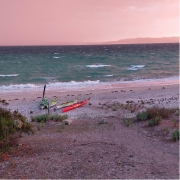
After loading kayaks (I overdid the equipment list again!) and after the safety briefing from Phil we set off at about 8.45am, following the coast east to Lands End to avoid the ferry’s path. We then set our bearing for Cape Coutts and headed out on our adventure, with a few whitecaps between us and the safety of Antechamber Bay; just east of Cape Coutts we were on our way.

A pleasant paddle across but no wind advantage which disappointed those with sails in the group, just a solid slog for 5 hours before we made Antechamber Bay, even explored a bit of the sandy beach to eventually reach Chapman River. Just checking that the mouth hadn’t moved!

Many hands made light work of the portage across the beach and we were soon paddling up the picturesque Chapman River, admiring the paper bark trees and new bridge as we approached campsite no 12 that Mike had kindly booked.

Setting Camp

After setting up camp most of us relaxed, enjoying the location while others went paddling to explore the upper reach of the Chapman River.

Once again the campground was pretty busy so we made an early appearance at the camp kitchen, admiring the stunning views. We had a very pleasant evening there – night solar lights might be handy, a note for future trips! The kitchen is very well set up and we spent the evening discussing kayaking adventures while being entertained by Tresh’s attempts to get his cooker operational.

Soon after we turned in and slept well, being serenaded by several Boobook Owls during the night. In the morning some fairy wrens visited, very elusive but I did manage to get a couple of pics as they checked out my tent.

Day 2 — The not so easy one

On our way to Antechamber Bay
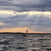
No rush in the morning with the plan to be on-water in Chapman River by 10am, bit of drizzle overnight and the additional time was put to good use sponging the tents and gear and getting packed up.  We said our farewells as we paddled under the KI version of Sydney Harbour Bridge and down to the mouth for another portage. The waters in the bay looked calm but the forecast for the crossing was increasing winds 15 to 20Kn SW. The sky towards Deep Creek threatened to bring squalls during our crossing.

The briefing was a bit somber and Phil gave the group the option of returning via the Penneshaw ferry instead of attempting a borderline crossing – we all mulled it over but the mutual decision was to paddle the return as the group was fired up to complete the crossing. These sort of situations are always difficult with experienced kayakers, particularly with several having done crossings in similar conditions.

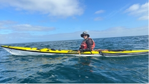
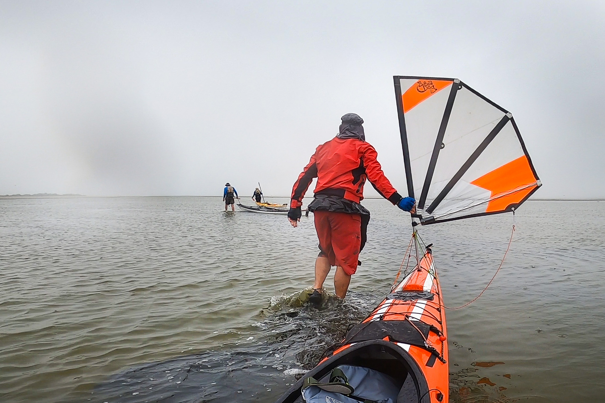
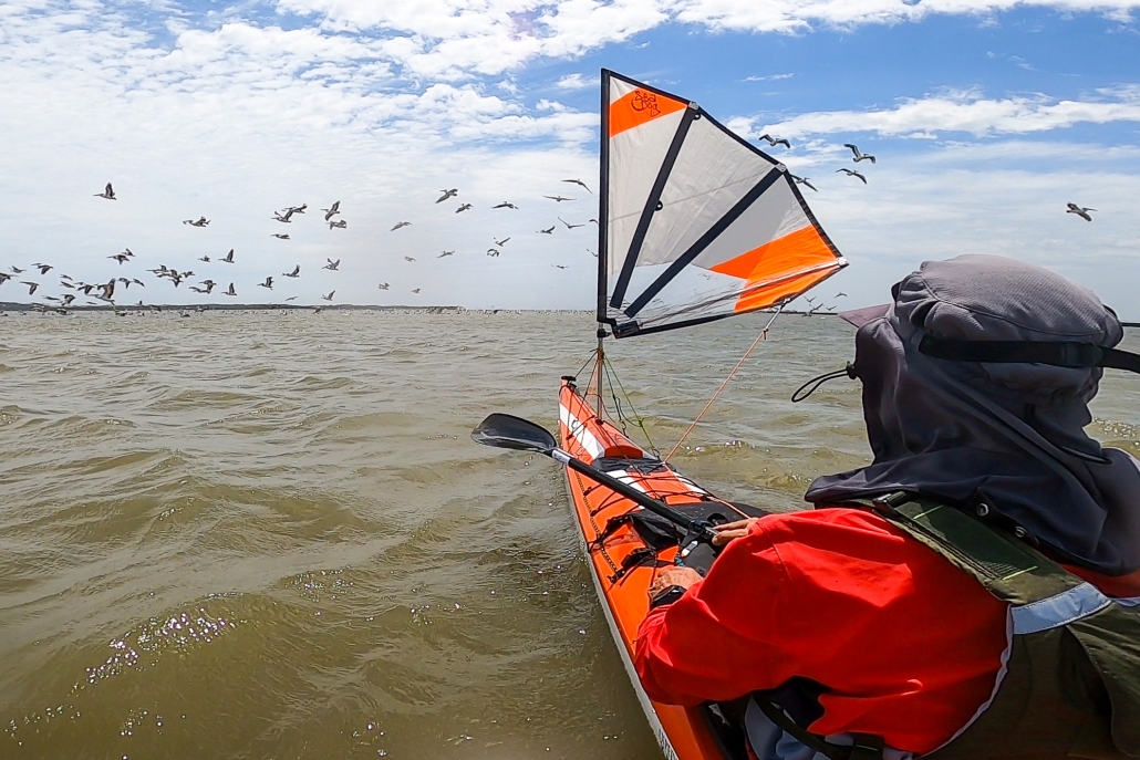
We split into sail-assisted kayaks and those just going with the swell, although on the starboard beam. We headed off together before separating into two groups, with those sailing heading directly across the passage towards Deep Creek before following the coast back to Cape Jervis while our group of five (5) made a beeline for Cape Jervis. There was no time to relax on the four (4) hour return paddle, it certainly required continuous attention.  Phew, all back in the safety of Cape Jervis boat ramp by 3pm.

Arrived

Together in the bakerySunday’s return crossing was by far the most challenging that I have done and I breathed a sigh of relief when we all arrived back at Cape Jervis safely, with the sailors having arrived about 15 minutes prior to the non-sail group.

Looking back, the return paddle was probably borderline, but to achieve the crossing without incident is a credit to the experience within the Adelaide Canoe Club. This is due to regular sea kayak training provided to Club members over several years particularly from Phil Doddridge, Bernard Goble and Peter Carter. All of the group are also regular paddlers, both at Club events and privately, regularly working on improving their skills. The paddlers conducted themselves in a very professional manner exhibiting a good appreciation of group dynamics to ensure we all remained safe.

All of us wanted to celebrate and swap stories, so we adjourned to the Yankalilla Bakery to debrief. And yes, the adrenaline was flowing strongly for quite a while afterwards!

Tour of Lefevre Peninsula

The Loop

Great suggestion from Mike Dunn on the WhatsApp channel on Friday for a paddle with a difference – doing a loop of the Lefevre Peninsula. The plan was to  launch from the Outer Harbor area, paddle down the Port River, portage across Bower Road into West Lakes, paddle south to Oarsman Reserve,  portage again across Military Road over the Tennyson Dunes and into the sea again – just in time to catch the southerly wind for the 13km final leg back to Outer Harbor. Distance was estimated to be about 28km. We had an ebb tide to begin the paddle so expected to work on our way up the Port River.

I felt I couldn’t resist Mike’s suggestion and was feeling pretty good about our Training Session at Tiranna Way on Friday so agreed to join up with Mike for his adventure.

The Start

Departure was from the small boat ramp just down from the Royal South Australian Yacht Squadron (RSAYS) at 9am, plenty of space for leaving our cars. Once we had loaded our very important trolleys for this paddle, as it requiring a couple of portage sections we were on our way by 9.30am.

Our sightseeing started with the Container Terminal – no shipping in sight so we explored underneath the concrete wharf which looked all very well maintained. As we approached Port River past the Snapper Point Power Station the ebb tide was very evident and even managed to practice some ferry gliding.

Mutton Cove Conservation Park

We had the river to ourselves as we paddled up past Mutton Cove Conservation Park. It’s great to see the increase in mangrove growth. This was a regular lunchtime break and the area has gradually improved, largely thanks to the local community group.

The regeneration of Mutton Cove Conservation Park become very evident as we approached ASC and were almost swept into mid channel by the tidal flow coming out from the small creeks that have been restored. This was all noted as a potential area for some whitewater skills practice when tides are favorable.

We made sure we were on the correct side of the Exclusion Zone buoys of the ASC building to ensure we didn’t set of any alarms. Brought back lots of fond memories to see a Collins Class Submarine on the Hardstand outside the Production Shed. The work on the Offshore Patrol Vessels (OPVs) seems to be progressing well with one in the water for final fit-out prior to Trials and another on the hard stand under construction.

Snowden Beach

Near Snowden Beach we spotted a small wooden boat in the distance. As it approached we saw it was skippered by club members Bernard and Frances Goble. They were doing a Sea Trial prior to departing for the Wooden Boat Festival in Hobart. Bernard had previously given Mike a call to advise that we might encounter them on water. We kept them company as we paddled into Port Adelaide and stopped at Cruickshanks Beach for a leg stretch and lunch.

After lunch our little flotilla continued on its way under the Birkenhead Bridge. We past all the construction happening around the old Fletches Dock and then up into Port Creek and what used to be called Port Misery when sailing ships moored there.

Crossing Bower Road

Water was becoming shallower as we approached the railway bridge before Bower Road. We said our farewell to Bernard and Frances. It was great having their company as we explored the Port. I’m sure our little flotilla was observed by a few of the locals.

We soon ran out of water after managing to navigate the many small rocks leading up to Bower Road. We must approach the council about a nice sandy beach for future trips! The portage across Bower Road went well, interesting dodging traffic with a 5m kayak in tow.

The new home for Paddle South Australia and West Lakes Canoe Club is looking near to completion. It should be a great venue for aquatic activities. We rolled our kayaks down to the beach and were soon back on water for the West Lakes leg of the paddle. Plenty of rowing activity around so we kept out of the way as we approached PAC Rowing Sheds and a busy event.

The forecast southerly had picked up as we approached West Lakes Boulevard bridge. And yet another surprise as we approached a group of kayakers – club members Bella and Anthony out on the water with visiting family.

Oarsman Reserve

We soon reached Oarsman Reserve and brought out our trolleys again. We navigated Military Road and found our way down to the beach via the backstreets of Tennyson. Much easier portage and no rocks to avoid.

The wind had certainly picked up and we searched the horizon for Matt Condon paddling his Audax up from Semaphore to join us on our final leg.

After safely getting through the surf on the Tennyson sandbar we headed further out and headed for Semaphore with Matt. Swell was on our beam and wind picking up so we delayed putting up sails until we reached Semaphore South when the wind was on our backs. I hadn’t used my sail for over 12 months. I asked Mike to stabilize my kayak until I got the Pacific Action rigged and we headed towards Largs Bay. All went well and Matt kept us company until Semaphore then headed back to his beach.

No wind

We had Outer Harbor breakwater in sight but the wind had dropped considerably. Down sails and back to paddling – just as well as the conditions as we rounded the breakwater were very messy but thankfully no water traffic around. Soon had the Overseas Terminal in sight then around the corner and back to our departure point. We both agreed we would sleep well that night after 32km and roughly 6.5 hrs in our kayaks. A fantastic paddle in various conditions with lots of interesting sites on the way.

Thanks Mike for organsing and many thanks to Bernard, Frances, Bella, Anthony (and family) and Matt for joining us during our adventure.  This is definitely a paddle that we will repeat, so keep your eyes on the calendar.

Kayaks in the beach in Coffin Bay

Coffin Bay — 7-11 November 2022

Head wind

The weather forecast for the week at Coffin Bay National Park was looking great as Bernard, Francis, Charlie, Marina and Anne set off from Coffin Bay township on Monday 7th November. With a 10-15 knot north easterly wind we paddled along the cliff edge on the northern side of the Bay We gained some advantage from the easterly component and sheltered from the northerly aspect until we crossed Mount Dutton Bay. The wind hit us again as we crossed above The Brothers Islands and made our way along the coast to Black Springs campsite. It wasn’t long

Seal behind a 2 person kayak with two sails up

Seal playing with the kayak at Coffin Bay

before we had set up camp and were relaxing.

Trying to get to Point Longnose

The plan for Tuesday was to paddle around Point Longnose and make our way to Morgans Landing camp. However, the forecast calm wind turned into at least 15 knots from the north and the swell was predicted to be about 2m. We battled into the head wind through the oyster farm to Point Longnose and beached the kayaks on the more sheltered side. Francis and Marina looked after the boats while Bernard, Charlie and Anne went to check conditions on the exposed side. The wind was very strong and it was whipping up waves which would have been breaking side-on to us along Seven Mile beach.

Back top Black Springs to see the eclipse

To continue would have given us about 12 km of very difficult paddling so we decided to retreat back to Black Springs. While we were checking conditions around Point Longnose a large wave and strong gust launched Charlie’s kayak back into the sea and quickly took it out of reach. Marina jumped into her kayak and managed to grab it but without a tow line to return it to the sandbar. She was stuck in waist deep water with a deep trench between her and the sandbar. We needed to work out how to reunite Charlie and his kayak. Bernard and Frances managed to ‘deck carry’ Charlie out to Marina and then it was easy to get everyone back into kayaks.

Moon eclipse in Coffin Bay

Moon eclipse in Coffin Bay

The strong northerly wind made sailing back a great option for those with sails. Anne and Marina decided to go around the coast while Bernard, Francis and Charlie planned to sail directly back. Luckily we did a radio check before we split the group and we had not gone far when we had radio contact that Charlie’s rudder wasn’t working and we collected together on the beach for repairs. That sorted we returned to camp, more or less as a group with some sailing nearer camp. In the evening as we walked along the beach we noticed the moon rising, but it didn’t look right. We checked Google and discovered we were seeing a total eclipse of the moon in progress.

Heading back

Wednesday’s winds were predicted to be even stronger and we woke up to rough seas and about 27 knot winds so we opted for a bushwalking day and visited the lookout to Black Rocks in Avoid Bay. We walked a little further along the cliffs and found an enormous Osprey nest perched on a rocky island, with the resident bird standing on top of it.

The wind forecast for Thursday was a westerly (tail wind returning to Coffin Bay) and Friday was back to easterly (head wind returning to Coffin Bay) so it didn’t take much discussion to pick Thursday as our last day. With a good tail wind we made our way along the coast then across to The Brothers Islands to check on the birds and seals there. There was one seal that swam around our kayaks checking us out as we photographed it.

Downwind from Seaclif — 1 February 2022

Downwind from Seacliff

Great Seacliff paddle Tuesday with four (4) paddlers (Phil, Mark, Anthony and Simon) braving the forecasted conditions of a 20kn southerly. Phil opted for a downwind run to West Beach to take advantage of the blow. Started off well, at least until we had a capsize just before the Brighton Jetty but soon on our way again.

No need for sail, just had to hang on and get blown up the coast! We had adjusted to the conditions just of Somerton Park, just as well as the wind started to increase with horizontal spray spreading out in front of our kayaks, an indication that wind speed was getting up to 30kn. Aside from the Temptation Catamaran, we were the only ones out on water. She was heading south with the deck covered in fun seeking sailors, we could see waves breaking over the bows.

Riding waves from Seacliff

The last leg from Glenelg to West Beach Boat Ramp was the most challenging, when we got hit by 1.5 to 2m waves forming on the sandbars. After gusts of 30kn plus hitting us, we opted to seek the shelter of West Beach Boat Ramp. A fantastic paddle and enjoy the pics – I managed to get a couple while keeping a good lookout for inbound swell.