
Multi-day kayak camping trip in the backwaters of the Murray river in the Chowilla reserve — 14 October 2022
Water Everywhere
There is a lot of water in the Murray at the moment. So much so that all the campsites in the parks are closed due to flooding. We even considered cancelling this trip. So glad we didn’t. Murray river may be high and flowing too strongly to paddle easily. But all the backwaters are even higher, with easy paddling and lots of normally dry creeks now easily navigable
The launch from near the Border Cliffs Campground was easy thanks to the high water levels. No scrambling down steep banks! We paddled slowly across the river as the current took us downstream to the entrance to Suders Creek. This creek is normally narrow and fast-flowing, and can be challenging. This time it was wide and easy. The usual obstacles were under water and we could paddle in amongst the trees that were normally high and dry on the banks.
From there we headed up Salt Creek and took advantage of the high water to investigate a normally dry creek. This route took us back to Hypurna Creek via some newly created wetlands. An unexpected treat was spotting a pair of wedge-tailed eagles, with what looked like a newly built nest. No sign of chicks, but it was hard to tell with the nest being so high. A short paddle up Hypurna Creek and we reached our campsite for the next two nights. We quickly put up tents, chairs and tables and we settled in to relax for the rest of the afternoon.
The Big Loop

Setting up camp
Next day was a relaxed start as we did not have to pack up camp. We did a nice easy circular route planned with unloaded kayaks, to bring us back to the same campsite. Started paddling slowly up Hypurna creek, which was sometimes confusing due to all the new channels which were now open, thank goodness for the trusty GPS. We were accompanied for a short period by some emus, which seemed curious more than alarmed, and allowed us to get really close. I guess they didn’t know what to make of these brightly coloured things floating on the water. When we reached Salt Creek we opted to take the longer route to the Murray, this is normally not navigable without a portage due to a causeway. This time there was no sign of the causeway or the bridge which were marked on the map.
We reached the Murray River, paddled a whole 100m downstream, and went back into the other entrance to Salt Creek. Must be the shortest distance I’ve ever paddled on the Murray. Our aim was to get back to a small creek which was not on the map, but now had plenty of water and was flowing from Salt Creek in the direction of Wilperna Creek, which was where we needed to go.
Wilperna Creek is normally a small, winding, snag choked place, today it was a broad, open river, and we made good time following the current downstream towards our campsite. All went well until a kilometre before the turnoff to the campsite, where we inadvertently took a wrong turn into yet another creek which wasn’t on the map. We soon realised our mistake, but the creek was flowing in the right direction, so we continued along and magically popped out into the right creek just above our campsite.
The Scenic Route

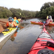
Paddling Hypurna Creek
Next day the camp was quickly packed up and everyone was feeling good. We decided to take a more scenic route back to the cars. We paddled down Hypurna Creek which, in places, resembled a lake rather than a creek, and spent our time trying to pick out the normal course of the creek amongst all the flooded trees. Then we bypassed the normal portage back to the Murray, and also Suders Creek (which we could have easily paddled up in the current conditions), and continued down Slaney Creek for another 3 kms to a small creek which joined up with the Murray.
We had never paddled this creek before due to the imposing regulator at the entrance, which is normally impassable without dragging kayaks up steep banks and through thick bush. This time the water had bypassed the regulator, and we all paddled past without even getting out of our kayaks.
Back in the Murray, we crossed over and hugged the bank out of the main current as we paddled the last kilometre back to the cars. Getting the laden kayaks out of the water was easy thanks to the conveniently high water levels. We were soon packed up and heading to Renmark for the customary debrief at the bakery.
Map and GPX file
Click in the image below to access the map of the trip and its corresponding GPX file

Wilperna and Hypurna Creeks


 Winds south westerly 0-5knots predicted felt like 8knots. The small group comprised of Simon Langsford, Peter McLeod, Matthew Eldred as trip leader. We gathered at Wally’s landing for the overnight paddle to Currency Creek. Peter was unable to stay the night due to work commitments and would return to the cars after lunch at Clayton Bay. We set off with the new paddle plan in place making our way through the reeds and into the lagoons to disturb the 100s of black swans that call it home.


 Launching from Garden Island boat ramp the group worked upwind across the Angus Inlet and some way up the Barker Inlet to get a fast downwind ride to the entrance to Hidden Creek. It has this name due to the entrance being indistinct and partially blocked by fallen trees. The entrance is on the eastern side of Eastern Passage just under the power lines. Once in the shelter of the creek conditions were ideal. Out of the wind it was much warmer, the water crystal clear and the winding nature of the creek made it feel adventurous! Phil and Bella were in a Mirage 730 double with Kaye and Stephen in their brand new Prijon double. Turning these longer kayaks to negotiate the ever sharpening bends tested sweep stroke technique, strength and endurance!
 Hindsight is a marvellous thing! Well before reaching the back of the creek we ran out of water, the tide was not quite ideal! And this is where the Bog challenge began! Those in single kayaks were able to turn around (just) to begin the journey out. No so those in double kayaks.
 There was no easy solution to get the M730 turned around so one end was shoved up onto the scrub and the rest lifted from the water to point it in the other direction. Phil and Bella then got in, taking quite a bit of smelly mud with them, and began paddling back. Well it was a mix of paddling, pushing off tree stumps and poling through the mud trying to weave through fallen branches and areas too shallow to float the boat!
 The wind was still blowing quite strongly so after a quick discussion Kaye and Stephen opted for a direct route back while others wanting more punishment headed on to the “Ships Graveyard”. It was a fun ride downwind and into the North Arm to view the remains of the Dorothy H Sterling and Santiago. These two relics are a link to the maritime past of South Australia. The Santiago was one of the first iron hulled ships ever made and was launched in Glasgow, Scotland in 1856. The Dorothy was launched in Oregon in 1920 and was one of the largest commercial sailing ships of it’s era. Unfortunately, it became a victim of the Great Depression. Upon arriving in Port Adelaide in 1929 it’s crew found that the company that owned the boat had gone bankrupt and no money was waiting for them for wages and landing fees. Eventually the Dorothy was impounded and put to auction to recoup the losses. The stunning six masted schooner was sold off for £50 then dismantled for scrap. The full stories of these relics can be found online.


