The Third Paddle in Tassie
Freycinet National Park was the third of three paddles in Tasmania. The awesome, challenging and varied sea states made this sea kayaking at its best! It’s why we went to Tasmania to go sea kayaking.
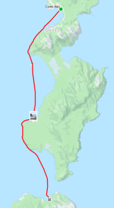
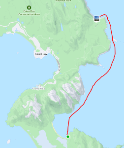
The plan for this part of the Tasmanian Odyssey was to be three days paddling and two nights camping out of the kayaks. The first and last nights in the area we camped at the National Park campground at Richardson Beach. The first day’s paddling was from Richardson Beach (Coles Bay) down the sheltered west side of the peninsula and across Schouten Passage to camp on Morey’s Beach on Schouten Island; approximately 24Km. The following day paddle up the seaward side of Freycinet Peninsula to the very sheltered campsite on the south eastern end of Wineglass Bay. This bay is listed as one of the 10 most stunning beaches in the world! About 22Km for the day. The final day was onto Bluestone Bay approximately 12Km. Prior to setting off, we left some cars at Bluestone Bay to allow the group to get back to Coles Bay once the paddling was done.
Day One-1st April
In discussing the likely conditions on the night before there was some concern at the forecast 20Kn southerly winds that we would need to punch into for the 24Km down to Schouten Island. The group decided to give it a go. We had contingency plans to camp at Cook’s Beach or one of the other pristine beaches along the way if all got too much.
All were on the beach ready for the challenge at the designated start time of 930am. Conditions were calm and glassy and the view south of the coast and high peaks just stunning. The first part of paddle down to Fleurieu Point was uneventful as the coast was sheltered from the winds. Once we reached the point and turned towards Hazards Beach we were into the southerly head wind and things got quite a bit harder. We were all pleased to pull in behind Refuge Island for a short break before pushing onto Cooks Beach camping area for lunch.
Leaving Cooks Beach we were again faced with a strong southerly as we paddled the remaining 12Km to Schouten Island to camp the night. Crossing Schouten Passage directly into the wind was a major challenge and seemed to take forever. We were all thoroughly done on reaching the very sheltered bay. The camp area was great as all got stuck into preparing a well-earned meal. Greg had the foresight to check the tides and informed the group that there was an exceptionally large tide in the early hours of the next morning. He suggested we all bring our kayaks up off the beach. If we had not done this the kayaks would have definitely drifted away as the tide consumed the beach and some of the access track that night!
Day Two-Wednesday 2nd April
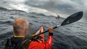
The forecast for this day was for a 2m swell but light winds so we looked forward to an easy trip up the coast. On paddling out of the shelter of the bay we met huge mountains of water charging down the channel between the island and the peninsula. The paddle up to Wineglass Bay was not going to be as easy as discussions the night before suggested. Most had not paddled in such a swell and those that had took time to adjust. Once out of the channel and heading north along the cliffs things got worse as the 4m swell hitting the cliffs gave huge rebound effects creating clapotis like waves.
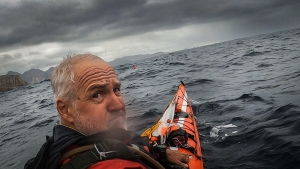
At times, when perched on top of a steep peak, it was hard to reach the water with your paddle! The leaders surveyed the group to ascertain if all were confident to continue as planned. Surprisingly all were up to it and after a time settled into the task with confidence. Being on top of one of the extra large swells and looking 5-6m down the face to the paddlers in front of the group was extraordinary. This day was a challenging, exhilarating paddle pushing everyone to their limits. We described it as “dirty dancing with the sea” or like “paddling in a washing machine”.
We didn’t take many pics on this day as it was all hands on the paddle to keep moving and keep upright!
The landing site at the campsite in Wine Glass Bay was tucked in behind a headland and protected from the huge swell that was thundering in like a steam train on the other side of the bay. The camp area was rather stunning with a stream of crystal-clear water flowing behind the camp and high peaks across the bay in the other direction.
Once rested, there was time to enjoy beautiful Wineglass Bay and a walk across the narrow isthmus to look at Hazards beach.
Thursday 3rd April
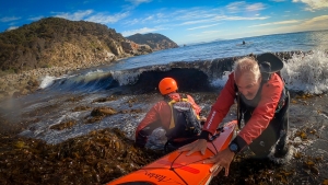
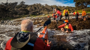
The last leg involved paddling past Cape Tourville Lighthouse and onto Bluestone Bay and was considered relatively easy after what we had been through the day before. The swell had mostly abated overnight and winds were almost calm. However we had some concerns about landing on a beach which was covered with large rounded boulders. Again the coastal cliffs, small islands and sea scape on the journey were stunning. There was much relief on arriving at the landing zone to see the rocks covered with a thick layer of kelp from the storm the day before. This provided a soft landing but a slippery crawl for people once out of their kayaks.
Timing was everything in such a landing. There was still a small swell running and the occasional larger set thumping into the rocks. The leaders set up a landing system where the group was marshalled outside the break zone and sent in one by one.
Those with plastic kayaks who were competent in landing in such conditions (Gordon & Charlie) went in first to survey the scene and select the best landing zone. Once ready others followed. The aim was to allow a wave to pass under the kayak and sprint in just behind it. This lessened the risk of being smashed into the rocks or the waiting helpers. Many in the group had practiced this in benign conditions back in Adelaide and this practice added to the smooth application when it was really needed! All landed with no damage done. Phil was last and was given the “Rolls-Royce” treatment of being hoisted right out of the water and up onto the kelp. He was much appreciative as he is not so nimble any more in exiting his kayak!
Dinner
We concluded the trip and told tall stories of the events of the last two weeks over dinner at Richardson’s bistro, Freycinet Lodge. What a fabulous adventure with such a diversity of paddling and incredible country to experience. All with good friends in Adelaide Canoe Club!
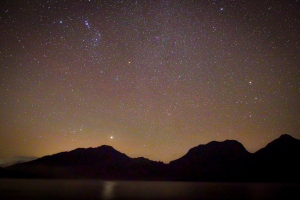
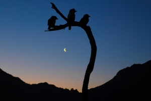
Acknowledgement to Greg and Karl our professional photographers for these amazing shots! Really captured the feeling of being in such a place!
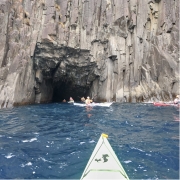
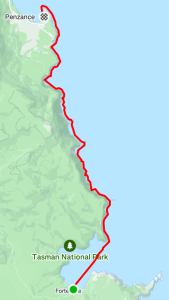
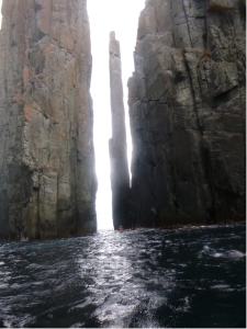 Our first day paddling from Fortescue Bay was out to Cape Hauy. There, we admired the dolerite columns called the Totem Pole and the Candle Stick. We had protection from the southerly wind as we skirted along the rocky cliffs and enjoyed the swell crashing in and the rebound waves. There was a sea eagle spotted perched on the cliff and it didn’t seem worried by our proximity. Within the protected area beside the Totem Pole and Candle Stick there were lots of seals that swam around our kayaks. Venturing further out on the exposed side of Cape Hauy the wind was quite strong and had generated waves which broke over the bow of kayaks almost to the cockpit. The group split; with some paddling around the outer islands, called The Lanterns, while others stayed on the sheltered side and paddled the northern side of these islands.
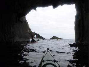 This day’s paddle was to the north from Fortescue Bay past the Devils Kitchen, Tasman Arch and the Blow Hole then into Pirates Bay finishing at the boat ramp. Because this was a one way paddle we organised a car shuttle to have a few cars at the landing spot.
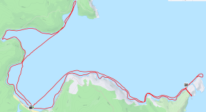


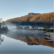
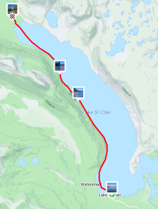
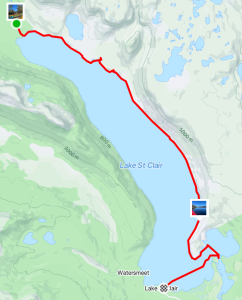
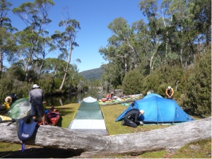 We set off at about 10am in perfect conditions, a slight breeze and blue sky. The tree covered hills of old growth forest and mountains in the distance provided stunning scenery as we paddled up to Echo Point for an early lunch stop. There was a tiger snake on the beach as we pulled in but it quickly disappeared into the scrub. Then it was on to Narcissus Hut, which is a short paddle up a small creek from the end of the lake. The landing spot at the hut was very steep so we paddled further up the creek and found a large, flat, grass-covered area and quickly had kayaks landed and tents up. A few people took advantage of the afternoon to go for a hike.
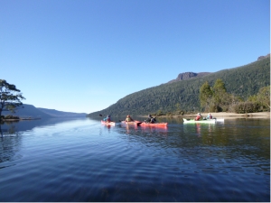 The glassy water was covered in mist as we paddled out from our creek and into the main lake. With the sun shining, we had amazing reflections of the trees lining the bank and the mountains. We paddled down the eastern side looking for a creek that came out from Lake Laura. The plan was to walk up the creek to see the lake. The attempt looked quite funny for those who opted not to try. The intrepid explorers were still visible, giving up after only a short distance, because the scrub was impenetrable and the creek rocks were difficult to negotiate.